What Is Q?

High Q is like a tuned bell. It resonates for a long time, but only at one frequency. Low damping; low bandwidth.


When reading about magnetic loop antennas, you often read that they are “high Q.” What on Earth is Q? Here is an intuitive explanation, drawn from the domain of music.

Imagine that you have a handbell, like you might hear in church music. Suppose that this bell has a very pure tone. i.e. It rings at its fundamental frequency, and has weak overtones. When you ring this bell, it resonates loudly at its fundamental frequency. As it sounds, the echo in the room is also at the fundamental frequency, reinforcing the continued sounding of the bell. The bell rings loudly, for a long time, on its fundamental frequency. If you were to look at the acoustic spectrogram of the bell’s sound, you would see a narrow, very tall spectrogram. The energy is concentrated in a narrow frequency range.

Now imagine a similar bell, with a bunch of dents in it. This bell has an impure tone. It rings at its fundamental frequency and also at many overtones and odd frequencies. When you ring this bell, its energy is spread across the audio spectrum. It doesn’t resonate for very long. If you were to look at the acoustic spectrogram of this bell’s sound, you would see a very broad, relatively short spectrogram. The energy is spread across a broad frequency range.

The first bell exhibits high Q. The second bell is low Q.

With a small, magnetic loop antenna, this is a high Q antenna. It is “willing” to be resonated only on its fundamental frequency. You have to change its fundamental frequency (via a variable capacitor) in order to resonate it on a different frequency.

With a big, dipole, where each leg is a quarter wave, fed with ladder line, this is a low Q antenna. You can use it on a broad range of frequencies. It is “willing” to be resonated outside its fundamental frequency.


In the equation for calculating Q, resistance (R) is in the denominator. Therefore, as resistance goes up, Q goes down. Because there is not a lot of wire to radiate, you need the little wire you do have to exhibit high Q in order to resonate effectively on the desired frequency. (You’re concentrating your radiation in a small bit of wire.) Since you need high Q, resistance is your enemy.
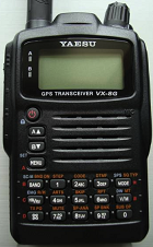
VX-8GR Guide for Smart People (not Dummies)

(I couldn’t call this page, “VX-8GR for Dummies,” because someone else owns the “for Dummies” trademark.)

VX-8GR Image

Here are some notes for getting started and quick reference when using my new VX-8GR. Notation is defined at the end of this page.

#Yaesu VX-8GR Set Up for APRS Beaconing

  • Note: Circle with dot in upper left, on Station List indicates that beaconing is active.
  • Enable GPS ++
  • Set call sign, SSID, icon (One time, when new.) ++
  • Enable APRS modem ++
  • Enter APRS (144.390) into the B frequency:
    • Tap <Bv> to select the B-band.
    • Use the digit keypad to enter 144.390
  • Enable Beaconing:
    • Access APRS Settings Menu ++
    • <turn> to 14: BEA- CON TX.
    • Tap menu
    • <turn> to Auto
    • Tap menu
    • to 12: BEACON INTERVAL.
    • Tap menu
    • <turn> to select interval
    • Tap <PTT> to save

#Enable APRS Modem

  • Access APRS Settings Menu ++
  • Turn to 3 APRS MODEM.
  • Tap <menu>.
  • Turn to 1200bps.
  • Tap <PTT> to save.

#Enable GPS

  • Tap <menu> until GPRS screen.
  • Hold <menu>.
  • Turn to select 18 GPS Power
  • Turn to toggle On/Off
  • Tap <PTT> to save On/Off
  • Note: <mode> toggles North-up/Heading-up. White arrow = heading-up; black arrow = north-up.
  • Tap <menu> to return to non-GPS mode.

#Set call sign, SSID, icon:

  • Access APRS Settings Menu ++
  • Turn to select 22 My Call Sign.
  • Tap <menu>.
  • Tap <mode> until pointer is in 7th call sign column.
  • Turn to select SSID -7 (unless you used -7 on other HT).
  • Tap <menu>.
  • Turn to 24 My Symbol.
  • Tap <menu>.
  • Turn to select running man.
  • Tap <menu>.
  • Turn to 23 My Position.
  • Tap <menu>.
  • Turn to GPS.
  • Tap <menu>.

#How to Use the Keypad

  • Multi-press the digit keys as you do on a cell phone, to cycle through the characters assigned to that digit.
  • Special characters:
  • <Band> is cursor-left
  • <Mode> is cursor-right
  • <Hm/Rv> appears to be select (and it stands for Home/Reverse)
  • To append an SSID to a destination address, complete entry of the base call sign and then rotate.
  • Lock/unlock = tap Power. Lock icon in bottom center shows lock status.
  • V/M is the Delete key (sometimes)
  • To enter “@”, press 1 and rotate clockwise 15. (It is right after “?”.)
    • Or press 0 six times for “?” and rotate clockwise 1.
  • To enter “.”, press 0 eight times or press 0 and rotate counter-clockwise 2.
  • Space is 00.

#Access APRS Settings Menu

  • Tap <menu> until Station List.
  • Hold <menu>.

#Send APRS Message

  • Tap <menu> until APRS MESSAGE
  • <Hm/Rv>
  • Enter call-sign-with-SSID (destination)
  • <mode>
  • Enter msg up to 67 char
  • Press TX/PO (the ‘atom’ key)
  • The radio tries 5x, one per minute. IF it gets an ACK, it puts an asterisk after the “TX” in the message display. Otherwise, it displays the remaining attempt count, or a period if it timed out.
  • To erase the current message buffer (to send a NEW message):
    • <Band>
    • A/B to select CLEAR
    • <V/M>

#Delete APRS Message

  • Select the message
  • Press <V/M>

#Yaesu VX-8GR Cheat Sheet

  • Volume - Hold_Vol + Turn_knob
  • Squelch - FW, Mon, Turn_knob, FW, Mon
  • MONI/T.Call = Suppress squelch
  • F/W = Alt (i.e. access the other function of the keypad)
  • Change transmit power = F/W + Atom
  • Check power level = L1/L2/L3/Hi in the lower-left on the display

Notes:

  • “Tap” means a brief button press.
  • “Hold” means to hold the button about 1 second, until its secondary function activates.
  • “Turn” means to turn the only knob on the radio. (Since the knob is the only thing that turns, I don’t say “Turn knob.”
  • ”++” means to see procedure defined elsewhere on this page.
  • “x+y” means “at same time”; “x,y” means “sequentially”
  • There’s a key in the lower left, with TX/PO as its alternate function, that looks like an atom with revolving electrons to me. I call this the ‘atom’ key.
  • BEEP-BEEP: If you press the atom key and it goes beep-beep, check to be sure the radio isn’t locked to frequency 1. If it is, hold “B” until it goes back to 2-frequency mode with 144.390 as the B frequency.

Keyword fodder: vx-8gr vx8gr vx8-gr

SOTA Activation Report: W4G/NG-003 Hightower Bald

SOTA Activation Report: W4G/NG-003, Hightower Bald

Trip of 2013.04.20

  • Succeeded: Yes
  • First-activation: Yes

See my trip planning guide at: SOTA Guide: W4G/NG-003, Hightower Bald

Commentary:

Hightower Bald (HTB) is activated and I’ll be stiff for a few days. ;-)

The weather was beautiful – High of about 60, a mild breeze, and not a cloud in the sky. I had hoped to make a joint activation of HTB with KI4SVM but he had to cancel.

The first part of the trek is hiking up a dirt road. I’ve been contemblating 4WD Forester or a CRV for driving to SOTA trails. I’m reevaluating, in light of this “road.” It has erosion gullies that are nearly knee deep, and I’d want a 4WD with big tires to drive it. Since I drive a compact car, I hiked this part.

Part 2 is the Appalachian Trail – always easy to follow. I am grateful to the volunteers who maintain it.

Part 3 was bushwhack. I left the AT near an unnamed gap just south of Bly Gap, which I christened “Gap Obvious” (because it is). Up Rich Knob, down to Hightower Gap; up unnamed hill, down to unnamed gap; up the ridge to HTB. A faint trail on parts of the ridge speeds this part of the trek. That’s good because I wasted a lot of time trying to skirt the summit of Rich Knob, and trying to regain the ridge line when I tried to skirt the dense brush on the final ascent of HTB.

Propagation was good. HTB has an unusually sharp peak for a Georgia summit, which helped. I made 21 contacts. I’m logging only 20, because I never did figure out an unusual phonetic substitution used by one contact (N8?Y). There may have been other chasers. I heard some faint calls right at my noise floor. If you called and I didn’t get you, I apologize for my ineptness. With more practice, I’ll either get better at operating weak signals.

I used a carbon fiber mast, partially extended to about 18’. My antenna was an end-fed 33’ wire in an inverted V. I used an EARCHI 20m matchbox. I used a 30’ counterpoise at about 4’ AGL. This should be unnecessary for 20m; I find that it helps with SWR for 40m. I should run 20m without it, and then remove the matchbox and connect the counterpoise and the antenna directly to my KX3. That would be a more ‘normal’ setup. I didn’t do that because I wanted to switch bands quickly. I don’t want my 40m activators to wander off to do something else while I mess with my antenna. (I use LMR-200 feed line, to minimize SWR-related loss between the transformer and my rig’s ATU.)

When I left the summit, my GPS briefly wigged out, and I made an unplanned side trip to Montgomery Corner (34.9867, -83.6199). I’m sure there’s an interesting story about why the state line makes this funny corner and I know that some people visit it intentionally. (It was an unremarkable sight, IMHO.)

I’m glad I got the GPS straightened out before going too far into North Carolina. From the GPS trace of my route, there’s an obvious point where I made a gradual turn 90 degrees left. I kept thinking that my shadow wasn’t where it should be. (When bushwhacking, I mostly navigate with reference to my shadow. e.g. ‘Follow my shadow’ or ‘keep my shadow off my right shoulder.’)

If my GPS is dead, I can use the GPS in my iPhone as backup, or use a topo and compass if I go for a swim and ruin my electronics, but I have to know my GPS is borked in order to make the switch. In this case, the GPS somehow tied its you-are-here to its cursor, so wherever I put the cursor, it said I was going straight that way. It wasn’t until I knew I had NOT been traveling in a perfectly straight line that I figured out the problem.

In planning the trip, I’d said that this it was at my absolute limit for a one day activation. That was accurate. I’d have been in trouble if I had to do another half mile. My last mile out was much slower than my first mile in. The total distance was OK, but bushwhacking straight up Rich Knob is a killer.

It was a good trip and I feel like I accomplished something. I’m sorta sorry to see the last of the un-activated Georgia 10-pointers get activated. Trying to get to them before someone else did has really motivated me to get off my duff and on the trail.

Thank you chasers!

  • NS7P
  • VE2JCW
  • K0NO
  • N1EU
  • VE1WT
  • VA6FUN
  • W0MNA
  • AE5KA
  • K0YO
  • KJ4ZGV
  • N4LA
  • W4ZV
  • K4PIC
  • AA4AI
  • WX4ET
  • K2UFT
  • KC3RT
  • W4MPS
  • N4EMG
  • N8QY
  • W4WNT

k4kpk.com

My name is Kevin Kleinfelter. I’m an amateur radio operator in the United States. I received my General Class license in 2012 and my Extra in 2015.

My radio chief interest is in SOTA. In short, I hike to the tops of mountains, set up a portable radio station, and make contact with other amateur radio operators around the world.

When one makes contact from a mountain, this is known as ‘activating’ the summit, and the people who do this are ‘activators.’ There are people who enjoy making contact with activators, and they’re known as ‘chasers.’ Activators and chasers do this in order to acquire points. The points have no value, they’re just a way to keep score. (Nobody cares about your score but you.)

If we have spoken via radio and I have asked you to “spot me,” it would be a big help to me if you would do so. When an activator is ‘spotted,’ it means that someone has posted the frequency where he is operating to a web site. Chasers watch this web site. Once I am spotted, a bunch of them will try to contact me. If I make 4 contacts, I’ll get my points. Otherwise, I’ll have to climb this hill another day and try again. To spot me, you’ll have to

  • Go to http://sotawatch.org/ and register for an ID/password via the ‘register’ link. (It isn’t hard, and they won’t spam you – at least they haven’t spammed me.)
    * Then you click on the “new spot” link and enter:
    • My call sign – K4KPK
    • My summit reference – that funky list of letters and digits I gave you which identify my hill
    • The radio frequency I am operating on
    • The mode I’m operating on. (e.g. SSB, AM, CW, etc.) * Then click the “Add Spot” button

I operate mostly in Georgia. Georgia has 14 summits which are 10-point summits (the highest number of points available for a summit). When a summit is activated for the first time, this is (cleverly) called a ‘first activation.’ I first-activated 7 of Georgia’s 14 summits. Other people got to the remaining 10-pointers before I did. I went on to activate the remaining seven 10-point summits in early 2013. I was the first activator collect the full set of all 14 of Georgia’s 10-point summits. In December of 2013, I completed my 50th activation. In September of 2014, I activated for the 100th time.

My favorite summit was Stratton Bald. My then-12-year-old son and I activated Stratton Bald on an overnight camping trip. This was my first summit. It was also my first QSO. I had planned this trip months in advance. Shortly before the trip, I received notice that the manufacturer would ship my radio to arrive a few days before our trip. I wasn’t going to cancel the trip, but I still wanted to play with my new toy. Then I read about SOTA. My son thought that the idea of first-activating Stratton Bald sounded pretty cool, so that’s what we did. We lucked out and I spoke with people in Germany, England and Canada, and I had a summit-to-summit contact with someone in Canada!

SOTA Activation Report: W4G/NG-020, Wildcat Mountain

SOTA Activation Report: W4G_NG-020, Wildcat Mountain

Trip of 2013.04.08

  • Succeeded: Yes
  • First-activation: No

See my trip planning guide at: SOTA Guide: W4G/NG-020, Wildcat Mountain

Commentary:

Despite some ominous gray clouds (and some gnats, which briefly drove my 13 year-old son nuts), we had a great time activating Wildcat Mountain (W4G/NG-020). It is always nice to have my son along. As I’ve mentioned before, he is the perfect trail companion: he keeps up, he doesn’t complain, he doesn’t natter, and he helps with antenna setup and with contact logging.

This is a brief hike at 35 minutes in and 25 minutes out. (We hustled, coming out.) The climb from the gap to the junction with the Whitley Gap Shelter trail is steep, but there are no large obstacles, and it is brief, at 0.2 miles. The side trail is blue-blazed and a pleasant walk. We were there before the laurel blooms, but I bet that will be pretty. There are some nice views along the way.

I had a little trouble with my “10 Meter Mini GRP Mast” from http://www.dx-wire.de/brit/. Although I thought I had firmly extended each section, it collapsed (section sliding into section) on me as I was setting it up. I usually just pull firmly to extend segments, having read that twisting can eventually cause de-lamination. This time I had to do some twisting, to make it stay extended. Also, I discovered that the threaded end cap was split. I suspect it was damaged when it was shipped to me, but since I didn’t notice it until I’d had the mast out a couple of times, I can’t say for certain.

We had a good turn out of chasers for a weekday on SSB, with both old and new friends on the contacts. Thank you chasers!

  • KD9KC
  • W0MNA
  • WB5USB
  • K4PIC
  • NS7P
  • AA0LV
  • AE4FZ
  • WA2USA
  • N4LA
  • W4ZV
  • W4WNT

SOTA Activation Report: W4G/NG-009, Horsetrough Mountain


Trip of 2013.04.06

  • Succeeded: Yes
  • First-activation: Yes

See my trip planning guide at: SOTA Guide: W4G/NG-009, Horsetrough Mountain

Commentary:

Trip of 2013.04.06

  • Succeeded: Yes
  • First-activation: Yes

See my trip planning guide at: SOTA Guide: W4G/NG-009, Horsetrough Mountain

Commentary:

Beautiful spring weather, a pleasant trail followed by a moderate bushwhack, and lots of contacts on the summit – this is why I summit.

My trailhead is accessed via USFS-44, and a section of the road washed out and was closed. I knew this section was near my trailhead, so I had some concern it wouldn’t be accessible. The road was gated about 100 feet past my trailhead. The trail up from 44 to Poplar Stomp Gap is a continuous climb, but it is never so steep as to be exhausting. The first half skirts a wildlife management burn. After it passes the fire break, it is like walking on a garden trail – an even surface with short grass and no evidence of recent vehicular traffic.

I’d spoken with a variety of people about the easiest route to Poplar Stomp Gap, including other activators, an official with the Georgia Appalachian Trail Conference, and the Forest Service. The FS person wasn’t entirely clear on where I was speaking of, and the GATC person said, “That route is outside our comfort zone,” and he proceeded to suggest a longer route, so I wasn’t sure of what to expect. To any future activator/hiker seeking to read Poplar Stomp Gap, this is definitely the easy route.

My bushwhack from the Appalachian Trail to the summit followed the approximate route which the AT followed 25+ years ago, but I could find no trace of the old trail.

I had more contacts on the summit than I’ve ever had before, with 3 S2S. The closest was KI4SVM, also in north Georgia, and the farthest was KD9KC in New Mexico. My thanks to the chaser who clued me in to Mike’s call. I’d have missed it otherwise.

As I was packing up, I heard rustling in the bushes and I was joined by the Atlanta Outdoor Club. It is unusual for me to meet anyone on a bushwhack, let alone 10 someones with 2 trail dogs. They scuffed around in the leaves looking for the benchmark and then they hurried back down the trail whence they came.

I drifted west on my return bushwhack, and the terrain kept pushing me west, so the trip downhill was longer than the trip up. Back at Poplar Stomp Gap, I encountered a solo backpacker who was consulting his AT guide. “Where ya headed?” I asked.

He responded, “Maine, I think. I hope I’m headed in the right direction!” It turns out that he just passed his Extra Class exam, so we chatted about rigs, antennas, and propagation.

A Grand Day Out.


SOTA Activation Report: W4G/NG-001 - Brasstown Bald

SOTA Activation Report: W4G/NG-001, Brasstown Bald

Trip of 2013.03.30

  • Succeeded: Yes
  • First-activation: No

See my trip planning guide at: SOTA Guide: W4G/NG-001, Brasstown Bald

Commentary:

I set off for Brasstown Bald with my 9 year-old son. I’d been looking for an easy summit to bring him along for his first SOTA experience, and Brasstown Bald has a paved trail from the parking lot to the summit. (He’s a talker – not a hiker.)

We scouted access to the Poplar Stump Gap Rd trailhead for Horsetrough Mountain along the way. There are some significant challenges to reaching that trailhead. That trip will be near the limit of what I can accomplish in a single day, so we took advantage of today’s easy trip to discover some closed gates.

Once we reached the parking lot for Brasstown Bald, we learned that they’re now charging $5 per adult admission and shuttle fee, even if you’re walking up to the summit! We walked up. (What is it about a child which compels him to sit on every bench along a trail?)

I set up near the building, on the highest ground I could find. I managed to self-spot via SMS by running around to the observation deck, and then running back to my rig to call CQ.

I was operating on 17 meters due to the CQ WPX contest. I heard from 3 SOTA chasers pretty quickly, then nothing. So I moved to another free spot on the band, thinking that maybe there was someone else on ‘my’ frequency who I couldn’t hear.

After another sprint, spot, sprint, I got back to my rig to hear S9+ noise. Something in the museum cranked musta started up. Maybe someone turned on a bad fluorescent light. The noise didn’t go away, so we relocated to a small clearing near the end of the trail to the summit.

I spotted again (complete with a sprint back to the observation deck), and called and called, but no joy. I suspect that the clearing, on a slope off the side of the summit, was steering my signal to the south. (I was getting great reception of a multi-lingual operator in St. Martin.) I was acutely aware that my kid was getting bored, and I was concerned that I would fail to get my points.

We had planned to try for an S2S with wGOAT, but with the noise and some delays on Steve’s end, and the limited attention span of a 9 year-old, that was clearly falling apart.

At this point, my son said to me, “Dad, do you actually think this in fun?” I’m thinking that not only have I missed my points, I’ve spoiled a perfectly good afternoon with my boy.

Finally, I switched over to 20 meters, made a QSO with a contester to snag my points, and we headed down the hill for cheeseburgers and ice cream.

In the end, it turned out to be a successful trip. I did get my points. Later, when we were home, my son said he was happy to have had a good day. I asked him about his, “Do you actually think this is fun?” remark, and he explained that he was fine with the afternoon, and that he had been expressing concern about me because I was clearly stressed.

Going forward, I’m going to re-think my approach to contests. I’ve been considering them an impediment to SOTA. I’m thinking that maybe a better approach would be to climb the hill and just work the contest for a while. If all the other hams are playing contest, why fight it? THEY certainly won’t care that I’m on a summit. I’ll need to enter the contest and submit my log to the contest, in order to ensure they get their credit for the QSOs, but that’s a small price to pay in order to make an activation successful when I can’t make contact with SOTA chasers.

Thank you to today’s chasers:

  • N6KZ - First time I heard from him.
  • K8TE - First time I heard from him.
  • W0MNA - Hooray for dependable W0MNA!

… and thanks to the contester, who couldn’t care less that one of his contacts was on a mountain. ;-)


How to Create a Cabrillo Log File For CQ WPX By Hand

I made one contact in the recent CQ WPX contest.

That wasn’t a failure. I wasn’t actually interested in the contest. I am interested in SOTA, and I was one contact short of the minimum number to claim points for my activation. I needed another contact, and there was a contest going on with lots of people wanting to make contacts…

Since I held a QSO with a CQ WPX contester, I consumed some of his time during the contest. In my ethical system, that obligates me to submit my log to the contest, in order to validate his QSO with me. CQ WPX wants its logs in Cabrillo format, so I needed to create a single entry Cabrillo file.

Step 1: Fetch the sample file from http://www.cqwpx.com/cabrillo.htm. Here’s what it looked like:

START-OF-LOG: 3.0
CALLSIGN: AA1ZZZ
CONTEST: CQ-WPX-CW
CATEGORY-OPERATOR: SINGLE-OP
CATEGORY-ASSISTED: NON-ASSISTED
CATEGORY-BAND: ALL
CATEGORY-POWER: HIGH
CATEGORY-MODE: CW
CATEGORY-TRANSMITTER: ONE
CATEGORY-OVERLAY: TB-WIRES
CLAIMED-SCORE: 9447852
CLUB: Yankee Clipper Contest Club
LOCATION: WMA
CREATED-BY: WriteLog V10.72C
NAME: Randy Thompson
ADDRESS: 11 Hollis Street
ADDRESS-CITY: Uxbridge
ADDRESS-STATE-PROVINCE: MA
ADDRESS-POSTALCODE: 01569
ADDRESS-COUNTRY: USA
OPERATORS: K5ZD
SOAPBOX: Put your comments here.
SOAPBOX: Use multiple lines if needed.
QSO: 7005 CW 2009-05-30 0000 AK1W 599 1 S50A 599 1
QSO: 7006 CW 2009-05-30 0000 AK1W 599 2 EF8M 599 2
END-OF-LOG:

Many of the new values I needed were documented on this same web page.

Step 2: Make the ‘obvious’ changes:

  1. Change CALLSIGN from AA1ZZZ to my call sign.
  2. Change CONTEST from CQ-WPX-CW to CQ-WPX-SSB.
  3. Change CATEGORY-BAND from ALL to 20M.
    • I ‘competed’ only on one band.
  4. Change CATEGORY-POWER from HIGH to LOW.
    • I used 12 watts.
  5. Change CATEGORY-MODE from CW to SSB.
  6. Delete CATEGORY-OVERLAY
    • Because I don’t care about entering in their categories.
  7. Delete CLUB.
    • I’m operating solo.
  8. Change WMA to GA.
  9. Delete CREATED-BY.
    • I did not use a program, and this line is optional.
  10. Change NAME and ADDRESS/ADDRESS-xxx locations to my values.
  11. Delete the OPERATORS entry.
    • Because I operated only as myself.
  12. Delete SOAPBOX entries.

Step 3: Enter my correct score and QSO entries.

  1. Change CLAIMED-SCORE to 1.
    • Contest rules state “Contacts between stations in the same country are worth 1 point regardless of band.” The go on to describe the use of the count of prefixes worked as a prefix multiplier, but since my prefixes-worked count is 1, this has no effect on my score.
  2. Delete existing QSO records
  3. Create one QSO record. This is a fixed field width record!
    • Column 01-04:
      • QSO:
        • Record identifier
    • Column 05 = space
    • Column 06-10
      • 14324
        • Operating frequency in kHz. Left pad with spaces.
    • Column 11 = space
    • Column 12-13
      • PH
        • In the QSO record, SSB is entered as “PH” for phone.
    • Column 14 = space
    • Column 15-24
      • 2013-03-30
        • Date of QSO in yyyy-mm-dd format
    • Column 25 = space
    • Column 26-29
      • 1620
        • Time of QSO in hhmm format (UCT).
    • Column 30 = space
    • Column 31-43
      • K4KPK
        • My call sign, right-padded with spaces.
    • Column 44 = space
    • Column 45-47
      • 59
        • RST sent, right-padded with spaces.
    • Column 48 = space
    • Column 49-54
      • 001
        • Serial number SENT
    • Column 55 = space
    • Column 56-68
      • WR5O
        • His call sign, right-padded with spaces.
    • Column 69 = space
    • Column 70-72
      • 59
        • RST received, right-padded with spaces.
    • Column 73 = space
    • Column 74-79
      • 549
        • Serial number RECEIVED
    • Column 80 = space

Step 4: Submission of the log.

  1. Upload log into http://www.cqwpx.com/logcheck/ and check it for validity.
  2. Use the same page to submit the log.

SOTA Activation Report: W4G/HC-001 - Cowpen Mountain

SOTA Activation Report: W4G/HC-001 - Cowpen Mountain

Trip of 2013.03.08

  • Succeeded: Yes
  • First-activation: Yes

See my trip planning guide at

Commentary:

Yesterday was a very good day. I almost got my car stuck twice, the trail which some maps showed wasn’t there, I got sick and my hiking companion remained sick – but I talked with British Columbia to the northwest and with Spain and the Canary Islands to the east!

Cowpen Mountain is in the Cohutta Wilderness Area of north Georgia, on a gated dirt road. I learned this the hard way on my first attempt, so I subscribed to the Forest Service’s “Alerts For Chattahoochee-Oconee National Forest” RSS feed. The feed confirmed that the gates were opened, as scheduled, on March 1. (I didn’t want to compete with the big contest on the weekend of March 2-3 so I didn’t go last weekend.) My boys had a school holiday on March 8, the weather forecast called for 0% chance of rain with a high of 50, so this looked like a perfect opportunity.

A few inches of snow remained on the ground from a mid-week snowfall. Nothing major – just enough for me to follow the footprints of another solo hiker in and out, without ever seeing him.

There’s a big trail from the trailhead to the ridge line, and some maps show a side trail from the main trail to the summit. If it’s there, it takes a better man than me to find it. The bushwhack wasn’t bad. It was a moderate grade with some briars under the trees for ‘spice.’

It shoulda been an easy hike up and an easy hike down. Coming down the mountain I got muscle aches and chills. My son, who was scheduled to come with me, had taken ill since the beginning of the week and it appears I came down with whatever-it-is on the hike down.

On the summit, I had a peculiar problem with my radio/antenna. I would dial-in 12 watts and the radio kept reducing power to 5 watts when I wasn’t looking. I’d call CQ a few times and observe SWR at 1-1 and power peaking at 10-12. A few minutes later, I’d look down and notice it was at 5 watts again. The reasons I know of for my KX3 to reduce power are high SWR or low battery voltage. I had a fresh 15V battery pack and SWR was 1-1 every time I looked.

I wonder if cell phone interference could cause this? I typically turn off my cell after I self-spot via SMS. This time I didn’t. Once in a while I did hear the cell phone’s GSM buzzing on my headphones. Perhaps this briefly altered SWR. I know it is a stretch, but I’m grasping at straws to explain the behavior. The only other explanation I’ve got is that this was my 13th summit, so my radio was bewitched. ;-)

There was something funky with cell signal too. Each time I pulled the phone out of my pocket, it showed 4 bars, but it would drop to 1 or none shortly afterward. The trick of holding the phone up high with the tips of my fingers did not recover service, but putting it back into my pocket did. I did this 4 times to confirm. The only way could get my self-spot out was to put the phone in my pocket.

There weren’t a lot of contacts, partly because it was a weekday and partly due to my antenna/radio problems, but I picked up my first contacts with British Columbia, Spain, and the Canary Islands!

Thank you chasers:

  • VE7CV
  • W0MNA (The day I don’t hear from W0MNA is the day I’ll send my radio for repair!)
  • W2MDW
  • EB2CZF
  • VE2JFM
  • EA8CER
  • KG3W
  • W4ZV
  • N4EX
  • AE4FZ
  • WH6LE

Trip of 2013.01.20

  • Succeeded: No
  • First-activation: N.A.

See my trip planning guide at: SOTA Guide - xxx/yy-000 - SummitName

Commentary:

  • Approach from the east: Found a seasonal gate closed on USFS-64 at 34.86457, -84.51989
  • Approach from the west: Found a seasonal gate closed on USFS-64 at 34.84140, -84.59441